
飓风伊达里亚是预计将登陆周三早上在佛罗里达州坦帕北部的大弯地区。
预计风暴在接近佛罗里达州时会进一步加强,可能会成为主要的3级飓风。
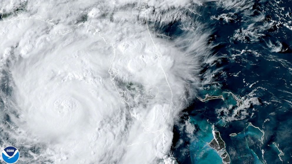
飓风伊达里亚仍为2级,风速达到每小时105英里
飓风伊达里亚仍然是2级风暴,持续风速高达每小时105英里。
伊达里亚正以每小时16英里的速度向北移动,现在距离佛罗里达州坦帕市155英里。
根据国家飓风中心的消息,佛罗里达的飓风和风暴潮警告已经对恩格尔伍德、朗博特基和坦帕湾生效。
伊达莉娅的飞行影响
随着伊达里亚的逼近,周二全美有超过2200架航班延误,超过500架航班取消。
到目前为止,超过500架美国航班取消。
目前,坦帕国际机场和圣彼得-克利尔沃特国际机场已经关闭。萨拉索塔-布雷登顿国际机场将于周二下午7点关闭。
德桑蒂斯说,现在是撤离的时候了
佛罗里达州州长罗恩·德桑蒂斯敦促被命令疏散的人现在就离开,如果他们还没有离开的话。
德桑蒂斯在新闻发布会上说:“如果你在疏散区,并且你被指示疏散,特别是如果你在低洼地区或沿海地区,在那个大弯地区,现在是时候这样做了。”“如果你等得更久,等到我们今晚更晚的时候,天气将开始变得越来越糟糕。”
佛罗里达州应急管理部主任凯文·格思里说,他“非常担心雪松基”,他预计那里的风暴潮将达到12至13英尺。
NationalOceanicandAtmosphericAdministration(美国)国家海洋和大气局
飓风伊达里亚正向佛罗里达州逼近,预计将在纽约登陆..
德桑蒂斯说,佛罗里达州的28个县现在都有某种形式的疏散命令,包括盖恩斯维尔的家乡阿拉舒厄县。他说,全州已经建立了50多个避难所。
美国国家飓风中心(National Hurricane Center)表示,预计爱达荷州将在一夜之间增强为3级飓风。该中心在最新的咨询报告中警告称,在一些大弯地区,“威胁生命的”风暴潮可能达到10至15英尺。
德桑蒂斯说,眼墙的影响预计将在周三早上的某个时候到达。
最新路径显示伊达莉娅在塔拉哈西东南部登陆
最新的路径显示飓风伊达里亚在塔拉哈西东南的北部大弯地区登陆。这比以前的路线更靠西一点。
预计爱达莉亚将于周三至周四带着热带风暴阵风和暴雨掠过佐治亚州南部和卡罗莱纳州。
孤立的龙卷风也是可能的。
由于风暴移动的速度很快,远离佛罗里达海岸的内陆地区可能会出现极端大风,甚至从盖恩斯维尔到瓦尔多斯塔都可能会出现110英里/小时的大风。
Idalia live updates: Forecast shows hurricane will be 'extremely dangerous'
Hurricane Idalia isforecast to make landfallWednesday morning in Florida's Big Bend area, north of Tampa.
The storm is expected to strengthen further as it nears Florida, possibly becoming a major Category 3 hurricane.
Hurricane Idalia remains Category 2, winds reach 105 mph
Hurricane Idalia remains a Category 2 storm with sustained winds up to 105 mph.
Idalia is moving at 16 mph to the north and is now 155 miles away from Tampa, Florida.
Hurricane and storm surge warnings in Florida are in effect for Englewood, Longboat Key and Tampa Bay, according to the National Hurricane Center.
Idalia's flight impacts
More than 2,200 flights Tuesday are delayed and over 500 flights are canceled across the U.S. as Idalia nears.
So far, more than 500 U.S. flights are canceled for Wednesday.
Currently the Tampa International Airport and St. Pete–Clearwater International Airport are closed. Sarasota-Bradenton International Airport is set to close at 7 p.m. Tuesday.
Now is the time to evacuate, DeSantis says
Florida Gov. Ron DeSantis urged people ordered to evacuate to leave now if they haven't already.
"If you are in an evacuation zone and you've been directed to evacuate, particularly if you're in a low-lying area or coastal area, in that Big Bend region, now's the time to do it," DeSantis said during a press briefing. "If you wait much longer, by the time we get in further into tonight, the weather is going to start getting nastier and nastier."
Kevin Guthrie, director of the Florida Division of Emergency Management, said he is "greatly concerned about Cedar Key," where he expects a storm surge of 12 to 13 feet.
DeSantis said that 28 counties in Florida now have some kind of evacuation order -- including Alachua County, home to Gainesville. Over 50 shelters have been set up throughout the state, he said.
Idalia is expected to intensify to a Category 3 hurricane overnight, according to the National Hurricane Center, which warned in its latest advisory that "life-threatening" storm surge could reach 10 to 15 feet in some of the Big Bend area.
The impact of the eyewall is expected to arrive sometime Wednesday morning, DeSantis said.
Latest path shows Idalia making landfall southeast of Tallahassee
The latest track shows Hurricane Idalia making landfall southeast of Tallahassee in the northern Big Bend area. This is a bit farther west than the previous track.
Idalia is then expected to skirt across southern Georgia and the Carolinas with tropical storm force gusts and flooding rain Wednesday through Thursday.
Isolated tornadoes will also be possible.
Extreme winds are possible far inland off the Florida coast because of how quickly the storm is moving -- even Gainesville to Valdosta could see 110 mph winds.